30 days refund guarantee
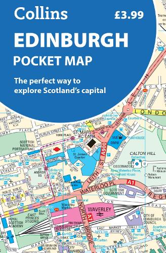
Edinburgh Pocket Map :The Perfect Way to Explore Edinburgh
Edinburgh Pocket Map :The Perfect Way to Explore Edinburgh
map
Published:
11 April, 2024
map
Published:
11 April, 2024
FREE Delivery by
Thu, April 9 - Fri, April 10
Order within
0
Eligible for Express Delivery by
Wed, April 8
Order within
0
Popular Books by Collins Maps
View All Books by Collins Maps
Description
Explore new places with handy pocket maps from Collins.
Handy little full-colour map of central Edinburgh with a high level of detail. Clear mapping from Leith in the north to The Meadows in the south, and Edinburgh Zoo in the west to Holyrood Park in the east.
Clear, detailed, full colour mapping is presented in a handy format ideal for the pocket or handbag. It is excellent value and covers the most visited area of central Edinburgh. It is an essential buy for tourists and residents alike.
This map includes:
• Detailed central area map
• Around Edinburgh map extending to airport, Pentland Hills and Forth Road Bridge
• Tourist locations
• Tram, train and bus stations
• Listing of major places to visit, with additional details for Edinburgh Castle and Holyrood Palace
• Detailed street index
• Now with NEW electric charge point data from Zapmap!
Map at a scale of 1:11,000 (6 inches to 1 mile).
More Details
| Type | Book |
|---|---|
| ISBN13 | 9780008663469 |
| ISBN10 | 0008663467 |
| Number Of Pages | 2 |
| Item Weight | 40 g |
| Product Dimensions | 90 x 140 x 6 mm |
| Publisher / Reseller | HarperCollins Publishers |
| Format | map |
See More +
Author's Bio
Explore the world through accurate and up-to-date mapping.