30 days refund guarantee
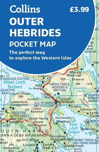
Outer Hebrides Pocket Map :The Perfect Way to Explore the Western Isles
Outer Hebrides Pocket Map :The Perfect Way to Explore the Western Isles
map
Published:
16 February, 2023
map
Published:
16 February, 2023
FREE Delivery by
Thu, April 9 - Fri, April 10
Order within
0
Eligible for Express Delivery by
Wed, April 8
Order within
0
Popular Books by Collins Maps
View All Books by Collins Maps
Description
Explore new places with handy pocket maps from Collins.
Handy little full-colour map of the Western Isles of Scotland. Detailed mapping and tourist information for the islands of Lewis, Harris, Uist, Benbecula, Barra and St Kilda. Excellent value and very detailed for its size.
Famed for its stunning coastline, wildlife and traditional food and drink, the Outer Hebrides have a distinct identity. Discover these unique islands with this handy pocket map.
Main features of this map include:
- Clear mapping at a scale of 3.2 miles to 1 inch
- Tourist attractions located and described
- Sights, places to stay, cafe/restaurant, things to do are all highlighted on the map
- Transport links map showing how to get to and depart the islands
- Index to places of interest and place names
Essential for those planning a trip around the Western Isles.
More Details
| Type | Book |
|---|---|
| ISBN13 | 9780008580056 |
| ISBN10 | 0008580057 |
| Number Of Pages | 2 |
| Item Weight | 30 g |
| Product Dimensions | 90 x 140 x 3 mm |
| Publisher / Reseller | HarperCollins Publishers |
| Format | map |
| Edition | 2nd Revised edition |
See More +
Author's Bio
Explore the world through accurate and up-to-date mapping.